The Best Pennsylvania Hikes: Local Favorites and My Hiking Bucket List
Looking for the best hiking trails in Pennsylvania? These are my favorite hikes, plus several bucket-list adventures still on my own Pennsylvania hiking list. As a lifelong Pennsylvania resident, I’ve spent years exploring the trails, state parks, and hidden corners of the Keystone State. Some of my favorite memories have happened on Pennsylvania trails—from hiking through endless fern forests on the Appalachian Trail to accidentally turning a family walk at Swatara State Park into a seven-mile adventure.
Pennsylvania doesn’t always get the same attention as places like the Smoky Mountains, Colorado, or the national parks out west, but I think that’s part of its charm. We have waterfalls, rocky overlooks, mountain vistas, dense forests, historic landmarks, and more miles of hiking trails than most people realize.
Note: The hikes below include both trails I’ve personally completed and a few iconic Pennsylvania hikes that are still on my own hiking bucket list. As I continue exploring Pennsylvania, I’ll update this guide with firsthand photos, trail reviews, and recommendations.
Whether you’re looking for a family-friendly nature walk, a challenging Appalachian Trail adventure, or one of the best overlooks in Pennsylvania, these are the hikes that deserve a spot on your list.
🥾 Pro Tip: Pennsylvania’s nickname among Appalachian Trail hikers is “Rocksylvania” for a reason. A good pair of hiking boots and a comfortable daypack can make all the difference on our rocky trails.
Why Pennsylvania Has Some of the Best Hiking Trails in the Northeast
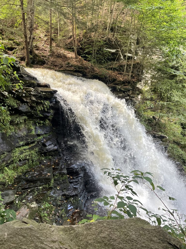
#1: Falls Trail — Ricketts Glen State Park
| 📍 Location | Luzerne, Sullivan & Columbia Counties |
| 📏 Length | 7.2 miles roundtrip (full loop with all waterfalls) |
| ⚡ Difficulty | Moderate — rocky, wet terrain near falls, some steep sections |
| 🌟 Highlight | 22 named waterfalls including stunning Ganoga Falls and Oneida Falls |
There is no trail in Pennsylvania quite like the Falls Trail at Ricketts Glen State Park. Period. If you only hike one trail in your entire Pennsylvania outdoor career, make it this one.
The Falls Trail system winds through old-growth hemlock forest past 22 named waterfalls — each one distinct, each one stunning. Ganoga Falls drops 94 feet, making it the tallest waterfall in Pennsylvania. But the true magic of the Falls Trail is the cumulative effect: waterfall after waterfall after waterfall, each appearing around the next bend like nature’s greatest highlight reel.
I’ve done this trail in fall and it was one of the most beautiful outdoor experiences of my life. The combination of cascading water, crimson and gold foliage, and ancient hemlocks is something I’ll never forget. Give yourself at least 4 hours, pack lunch, and take your time.
- 🥾 Wear waterproof hiking boots — the trail is wet near every waterfall
- 🥾 Don’t rush — sit by the waterfalls, eat lunch, take it all in
- 🥾 Visit in fall for extraordinary foliage or late spring for peak water flow
- 🥾 Book your campsite early if you want to stay overnight — Ricketts Glen fills up fast
👉 Read my full Ricketts Glen State Park guide including camping tips, kayaking Lake Jean, and our best stargazing moments!
#2: Appalachian Trail — Pennsylvania Sections
| 📍 Location | Runs across Pennsylvania from the Delaware Water Gap to the Maryland border |
| 📏 Length | Approximately 229 miles across Pennsylvania |
| ⚡ Difficulty | Moderate to Difficult — famously rocky terrain |
| 🌟 Highlight | Kimmel Lookout, Peters Mountain Overlook, endless fern forests, historic AT landmarks, and panoramic valley views |
The Appalachian Trail’s 229-mile Pennsylvania section is famously known among hikers as “Rocksylvania”—and after hiking several Pennsylvania AT sections myself, I can confirm the nickname is well-earned. Pennsylvania features some of the rockiest terrain on the entire Appalachian Trail, with long stretches of uneven footing that can challenge even experienced hikers.
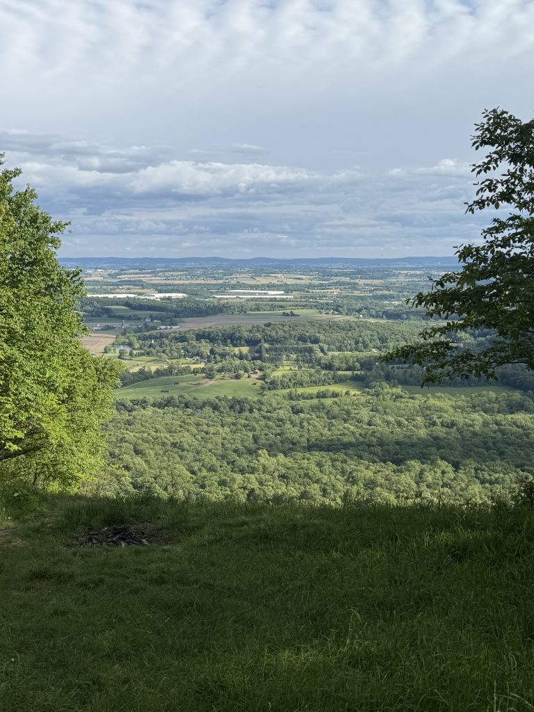
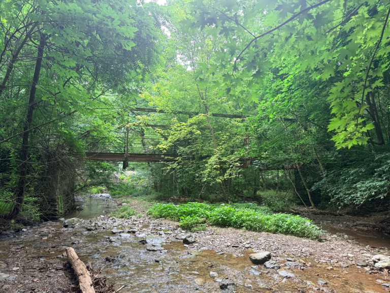
Despite the rocks, Pennsylvania’s AT offers some of the most rewarding scenery in the state. One of my favorite sections is the Green Point Trailhead to Kimmel Lookout hike, a challenging 12.9-mile route featuring the historic Waterville Bridge, beautiful fern-filled forests, scenic overlooks, and sweeping views across the Lebanon Valley from Kimmel Lookout.
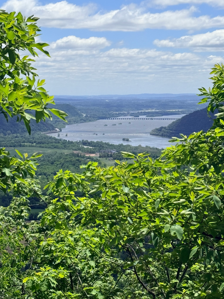
Another standout section is the Peters Mountain to Clarks Ferry hike, which includes rocky ridge walking, several impressive overlooks above the Susquehanna River, and one of the most memorable viewpoints in Central Pennsylvania.
Whether you’re looking for a shorter overlook hike or a full-day Appalachian Trail adventure, Pennsylvania offers countless opportunities to experience the AT without committing to a multi-day backpacking trip.
🥾 Expect rocky terrain and wear sturdy hiking footwear
🥾 Many Pennsylvania AT sections require careful footing and can be more strenuous than mileage alone suggests
🥾 Keep an eye out for white blazes that mark the Appalachian Trail route
🥾 Timber rattlesnakes and copperheads inhabit some AT sections—stay alert, especially in rocky areas
🥾 Pennsylvania’s Appalachian Trail is one of the best places in the state for scenic overlooks, ridge walks, and challenging day hikes
#3: Swatara State Park Trails — Lebanon CountyPark Trails — Lebanon County
| 📍 Location | Lebanon County, South-Central PA |
| 📏 Length | Multiple trails; 2–7+ miles depending on route |
| ⚡ Difficulty | Easy to Moderate — varied terrain, great for all levels |
| 🌟 Highlight | Bordner’s Cabin and the Appalachian Trail connection |
Full disclosure: Swatara State Park is my backyard — I live just down the road in Lebanon County, and I’m still discovering new things about it every time I visit. That’s the thing about Swatara: it’s deceptively large, beautifully diverse, and one of those parks that reveals itself slowly over many visits.
The park offers a beautiful mix of hiking trails, mountain biking trails, dense forest, and stunning views along Swatara Creek. The Appalachian Trail runs nearby, making Swatara a fantastic launching point to access one of the most iconic long-distance trails in the country. The hidden gem within the park is Bordner’s Cabin — a rustic historic cabin tucked into the woods that feels like stepping back in time.
A word of advice: bring a map. What looks like a short casual loop can turn into a 7-mile adventure through beautiful forest — ask me how I know! But honestly? That accidental 7-mile hike with my kids turned into one of our favorite memories. Sometimes getting a little lost is the whole point.
👉 Read my complete Swatara State Park guide including trail tips, gear recommendations, and the Appalachian Trail connection!
A Note From Me
I’ve personally hiked the trails above and included links to my detailed trail guides. The hikes below are some of Pennsylvania’s most recommended destinations and are currently on my own hiking bucket list. As I complete them, I’ll update this guide with firsthand photos, trail notes, and recommendations.
🌲 Hikes I’ve Personally Completed
🥾 Swatara State Park
🥾 Appalachian Trail: PA 183 to Route 501
🥾 Green Point to Kimmel Lookout
🥾 Peters Mountain to Clarks Ferry Trailhead
The remaining hikes are currently on my own Pennsylvania hiking bucket list and will be updated with firsthand trail reports as I complete them.
#4: Ferncliff Peninsula & Cucumber Falls — Ohiopyle State Park
| 📍 Location | Fayette County, Laurel Highlands |
| 📏 Length | 2.2 miles (Ferncliff loop) + 1 mile to Cucumber Falls |
| ⚡ Difficulty | Easy to Moderate — well-maintained, suitable for most hikers |
| 🌟 Highlight | Ohiopyle Falls on the Youghiogheny River and stunning 30-foot Cucumber Falls |
Ohiopyle State Park in the Laurel Highlands is one of Pennsylvania’s most action-packed outdoor destinations — white-water rafting, rock climbing, mountain biking, and some of the state’s best waterfall hiking all in one place. But it’s the Ferncliff Peninsula and Cucumber Falls that belong on every PA hiker’s bucket list.
The Ferncliff Trail is a 2.2-mile loop around a peninsula formed by a dramatic bend in the Youghiogheny River, passing by the thundering Ohiopyle Falls along the way. Combine it with the short walk to Cucumber Falls — a gorgeous 30-foot cascade tucked in a shaded gorge — and you have one of the most rewarding half-day hikes in the state.
Don’t miss the Natural Waterslides — a unique geological feature where the river has carved through sandstone to create a natural water park. On hot summer days, this is one of the most fun outdoor experiences in all of Pennsylvania.
- 🥾 Ohiopyle is easily a full day — plan to do both the waterfall hikes and the Natural Waterslides
- 🥾 The town of Ohiopyle has great food — Falls Market is highly recommended after a hike
- 🥾 Summer weekends are very busy — visit on weekdays or in shoulder seasons if possible
- 🥾 Outfitters in town rent bikes, kayaks, and rafting gear
#5: Canyon Vista Trail — Worlds End State Park
| 📍 Location | Sullivan County, North-Central PA |
| 📏 Length | 4.0 miles loop |
| ⚡ Difficulty | Difficult — steep climbs, rugged terrain, significant elevation gain |
| 🌟 Highlight | Canyon Vista at 1,750 feet — sweeping views of the Loyalsock Creek Gorge |
Worlds End State Park is one of Pennsylvania’s best-kept secrets, and the Canyon Vista Trail is the crown jewel of this dramatic north-central PA gorge. The trail rewards determined hikers with a sweeping view of the Loyalsock Creek Gorge from 1,750 feet elevation — a landscape that looks more like something from a national park than a state park.
The hike itself is genuinely challenging with steep climbs and rugged terrain, but the Canyon Vista payoff is absolutely worth every step. June brings spectacular mountain laurel blooms along the trail, while October transforms the gorge into a sea of gold and crimson that makes this one of Pennsylvania’s premier fall foliage destinations.
- 🥾 The Canyon Vista Trail is rated Most Difficult — prepare accordingly
- 🥾 Download trail maps before you go — cell service is nearly nonexistent
- 🥾 The Rock Garden adjacent to the vista is worth exploring
- 🥾 Visit in June for mountain laurel or October for peak fall foliage
#6: Kildoo Trail — McConnells Mill State Park
| 📍 Location | Lawrence County, Western PA |
| 📏 Length | 3.0 miles loop |
| ⚡ Difficulty | Moderate — rocky terrain, river crossings via bridges |
| 🌟 Highlight | The 1874 McConnells Mill Covered Bridge surrounded by glacier-carved boulders |
The Kildoo Trail at McConnells Mill State Park is rated 4.7 stars on AllTrails from over 3,000 reviews — and every single one of those stars is deserved. This 3-mile loop through the Slippery Rock Creek Gorge delivers historic scenery, dramatic geology, and stunning natural beauty in a perfectly sized half-day hike.
The trail takes you past the beautifully preserved McConnells Mill Covered Bridge — built in 1874 and listed on the National Register of Historic Places — and the historic gristmill that gives the park its name. The gorge itself was carved by glacial lake drainage thousands of years ago, leaving behind massive room-sized boulders scattered throughout the forest that make the landscape feel completely otherworldly.
- 🥾 Visit in spring when ephemerals are blooming along the creek banks
- 🥾 The east side of the trail (mill side) is rockier than the west side — good boots essential
- 🥾 Hell’s Hollow Falls is a separate easy 0.5-mile walk well worth the detour
- 🥾 Download the park map — there’s no visitor center on site
#7: Delaware Water Gap — Appalachian Trail Ridge
| 📍 Location | Monroe & Northampton Counties, Eastern PA |
| 📏 Length | Multiple options: 2–15+ miles |
| ⚡ Difficulty | Moderate to Difficult — significant elevation on ridge trails |
| 🌟 Highlight | Sunfish Pond and sweeping views of the Delaware River far below |
At the eastern border of Pennsylvania where the Delaware River slices through the Kittatinny Ridge, the Delaware Water Gap National Recreation Area offers some of the most dramatic scenery in the entire state. The Appalachian Trail climbs steeply from the river valley to ridge-top views that stretch for miles in every direction.
Sunfish Pond — a glacial lake perched atop the ridge — is the crown jewel destination for hikers in this area. The 9-mile roundtrip hike from the Delaware Water Gap trailhead to Sunfish Pond and back is one of the most rewarding full-day hikes in Eastern Pennsylvania. The views of the Delaware River Valley from the ridge are simply stunning.
- 🥾 The steep climb from the river to the ridge is challenging — start early and pace yourself
- 🥾 Sunfish Pond is the turnaround destination for most day hikers
- 🥾 The Dunnfield Creek Trail is an easier alternative following a beautiful mountain stream
- 🥾 This area is popular on fall weekends — visit on weekdays for a quieter experience
#8: Laurel Highlands Hiking Trail
| 📍 Location | Fayette, Somerset & Westmoreland Counties |
| 📏 Length | 70 miles total (Ohiopyle to Johnstown); multiple day hike access points |
| ⚡ Difficulty | Difficult — sustained ridge hiking, significant elevation changes |
| 🌟 Highlight | High-altitude ridge views of the Laurel Highlands stretching for miles |
For Pennsylvania’s most serious hikers and backpackers, the 70-mile Laurel Highlands Hiking Trail is the state’s ultimate multi-day adventure. Running from Ohiopyle State Park to Johnstown along the crest of Laurel Ridge, this trail passes through some of the most beautiful and remote terrain in South-Central Pennsylvania.
Day hikers can access the trail from multiple trailheads for shorter out-and-back adventures without committing to the full 70 miles. The sections near Ohiopyle are particularly spectacular, passing through old-growth hemlock forests, over rocky ridgelines, and past seasonal waterfalls. Eight overnight shelters are spaced along the trail for backpackers.
- 🥾 Day hike sections are accessible from multiple trailheads along PA Routes 381 and 653
- 🥾 The trail is blazed in yellow — easy to follow on clear sections
- 🥾 Backpackers must make shelter reservations through the PA DCNR reservation system
- 🥾 Spring and fall are the best seasons — summer can be hot and buggy on the ridge
#9: Cook Forest State Park — Cathedral of Pines
| 📍 Location | Clarion & Forest Counties, North-Central PA |
| 📏 Length | Multiple trails 1–5 miles; River Trail and Longfellow Trail most popular |
| ⚡ Difficulty | Easy to Moderate — gentle terrain through extraordinary old-growth forest |
| 🌟 Highlight | The ‘Cathedral Area’ — 300+ year old white pines and eastern hemlocks standing 175 feet tall |
Cook Forest State Park contains one of the last remaining stands of old-growth eastern white pine and hemlock in Pennsylvania — trees that were already centuries old when William Penn arrived in the New World. Walking through the Cathedral Area at Cook Forest is unlike any other outdoor experience in the state.
The trees here are simply staggering. White pines standing 175 feet tall, hemlocks over 300 years old, a forest canopy so dense it creates its own cathedral-like atmosphere of filtered light and deep quiet. The National Audubon Society has designated this area a National Natural Landmark — one of only a handful in Pennsylvania.
The Longfellow Trail winds through the heart of the old-growth forest for about a mile — short, easy, and absolutely breathtaking. Combine it with the River Trail along the Clarion River for a perfect half-day in one of Pennsylvania’s most extraordinary natural places.
- 🥾 The Cathedral Area is the must-visit section — start at the Forest Cathedral parking area
- 🥾 Visit on a weekday morning for the quietest, most atmospheric experience
- 🥾 Log Cabin Inn offers charming overnight accommodations right in the park
- 🥾 The Clarion River is excellent for canoeing — rentals available nearby
#10: Promised Land State Park — Lake Loops & Forest Paths
| 📍 Location | Wayne County, Pocono Mountains |
| 📏 Length | Multiple trails; 3–10 miles depending on route |
| ⚡ Difficulty | Easy to Moderate — relatively flat, great for families and beginners |
| 🌟 Highlight | Promised Land Lake and Lower Lake — beautiful reflections, excellent wildlife viewing |
Tucked in the Pocono Mountains of Wayne County, Promised Land State Park offers a more gentle and accessible alternative to the rugged terrain found in many PA state parks — without sacrificing any of the beauty. Two stunning lakes, miles of forested hiking trails, excellent wildlife viewing, and a campground that fills up for good reason.
The park’s trail system circles both Promised Land Lake and Lower Lake through dense second-growth forest that provides excellent habitat for wildlife. Great blue herons, bald eagles, beavers, white-tailed deer, and black bears are regular sightings. The lake reflections in early morning are photographer’s gold.
For families, beginners, or anyone who wants beautiful PA outdoors without the extreme elevation changes and rugged terrain of other parks on this list — Promised Land is the perfect destination. It’s particularly spectacular in fall when the surrounding hardwood forest erupts in color. Whether you’re tackling local favorites or checking off bucket-list destinations, the best hiking trails in Pennsylvania offer something for every skill level.
- 🥾 Book camping reservations months in advance — Promised Land fills up fast
- 🥾 The lake loop trails are perfect for families with children
- 🥾 Visit at dawn for the best wildlife sightings and lake reflections
- 🥾 Swimming is available at the beach area in summer
🌲 More Pennsylvania Hiking Adventures
Pennsylvania’s hiking trails have a way of surprising you. Sometimes it’s a sweeping overlook at the end of a challenging climb. Sometimes it’s a hidden waterfall you weren’t expecting. And sometimes it’s accidentally turning a short family walk into a seven-mile adventure because you missed a trail marker. (Ask me how I know. 😄)
As I continue exploring Pennsylvania, I’ll keep updating this guide with new hikes, trail reports, photos, and recommendations.
If you’re looking for more Pennsylvania hiking inspiration, check out some of my favorite adventures so far:
🥾 Appalachian Trail: PA 183 to Route 501
🌄 Green Point to Kimmel Lookout
❤️ Peters Mountain to Clarks Ferry Trailhead
Have a favorite Pennsylvania hiking trail I should add to my bucket list?
Drop a comment below and tell me where I should explore next! ☀️🥾
🎁 Pennsylvania Hiking & Outdoor Printables
If you’re as obsessed with Pennsylvania’s outdoors as I am, I also create Pennsylvania-themed printable activities and journals inspired by the places I write about here.
Current favorites include:
🥾 Pennsylvania Appalachian Trail Word Search
🌲 Pennsylvania State Parks Word Search
🦅 Pennsylvania Birds Word Search
🐻 Pennsylvania Wildlife Word Search
📓 Pennsylvania Hiking Trail Journal
Perfect for rainy days, road trips, classrooms, gifts, or keeping track of your own Pennsylvania adventures.
👉 Browse all Pennsylvania outdoor printables in my Etsy shop.